Thursday, June 16, 2011
June 16th, 2011 - Update
Well after a somewhat promising start for the area in April, May into June has been very disappointing in the East Texas area where I now reside. There have been a few spotty thunderstorms in the area from time to time, but it has been very hot and dry for the most part as an upper ridge has settled into the area for quite some time now. I am hoping for some relief in the form of slightly cooler temperatures and increased thunderstorm chances by the middle of next week. The chase season may be over in this region, but I would like to see more thunderstorms in the area to help with the drought and maybe give me an opportunity to shoot some lightning! We'll just have to see what the summer is going to bring me.
Sunday, April 24, 2011
April 23rd, 2011 - Sherman, TX Supercell, Wallclouds, and Lightning
I intercepted a beautiful supercell just west of Sherman, TX. This storm produced several awesome wall clouds. There were a couple reports of brief tornado touchdowns, but I did not witness any. I didn't always have the best vantage point and I stayed back for some fantastic storm structure photography.


In these next two images, the wall cloud becomes really well defined and starts to crank up. Too bad for those trees in the way which blocked any view of the ground, but it did not look like any tornadoes touched down from these views. It was close! I just don't think we had enough low level inflow into the storm to get the job done.


I moved to different location to get a closer view. The wall cloud was becoming less defined now, although it did put out some weak funnels which didn't amount to much. This storm was starting to get overrun by convection from the west and began to look more linear. I could feel cool outflow eventually before I left.


On the way back home I stopped and took a few decent lightning pictures. A nice end to a good chase!


Happy Easter everyone!
Saturday, April 16, 2011
April 14th, 2011 - Tushka, Oklahoma
Storms fired along a dryline through Kansas and Oklahoma late in the afternoon. After getting off a late start, I left Tyler, TX and headed northwest towards the Red River Valley, where I hoped storms would continue to fire along the dryline into north central Texas. I stopped for data when I reached Bonham, TX. No storms fired to my west, but I could see the monster supercell in Oklahoma off in the distance. I decided to head north into Oklahoma even though it would be near sunset by the time I could intercept. The road options in this area are terrible. I followed Bob's Road to continue in a northward direction. I eventually had a pretty good view of the storm from the south, but I was still a good distance away.
I realized that it would be too dark to attempt any meaningful intercept of the storm, but since I had already come this far I wanted to attempt some lightning photography. I continued driving closer to the storm, having to zig-zag along the Oklahoma highways. I made it to US 69 and drove northeast. The storm looked very intense, and a tornado warning was issued. I followed an ambulance from a distance. I was looking for a suitable place to take pictures from, but trees and valleys offered pitiful views. I told myself I would not go any farther than Tushka, since going any farther north would put me in the path of the storm heading that way.
I eventually ran into a damage path as I approached Tushka from a tornado that went through there less than an hour earlier. The town smelled strongly of freshly mowed wet grass. I saw overturned semis, downed powerlines/trees, and damaged buildings. It was not a good feeling at all to drive into a town after it was just hit by a tornado, seeing rescue efforts in full force. I turned around and headed back home since I had no emergency gear to help in my vehicle. I didn't want to get in the way any more than I already was. I was very sad to hear about the two fatalities. My thoughts and prayers are with this community.
This experience has definitely reaffirmed the need for me to put together an emergency kit in case I come across the damage path of a tornado on future chases. Many storm chasers have such a kit to some extent, and many will end their chase to stop and help search and rescue efforts in tornado damaged houses/communities. Kudos to all other storm chasers who have stopped to help storm victims in any way.
Sunday, April 10, 2011
April 9th, 2011 - Northwest Iowa Monster Supercell
Wow, what an evening. I chased with a friend of mine, who had never been chasing before. We left Des Moines around 2:30 PM and headed west to Avoca, IA. Stopped for some data at the Pilot truck stop. Nothing was happening yet so we killed some time and drove around a state park a little ways to the north. Then we went to Harlan, IA and found another WIFI hotspot and got more data. By this time the storm of the day had initiated in Nebraska. I waited around for just a little while to see if anything looked like it would develop farther south, but finally made the decision to intercept. We went north to Denison, IA, but could not find any WIFI quickly, but heard the thunderstorm warning and then the first tornado warning for Monona county to our northwest and headed northwest to Charter Oak, IA. By this time the beautiful mesocyclone became obviously apparent. We took some county roads north and parked on top of a hill somewhere west of of Ricketts, IA.
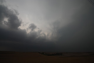
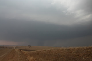
As the storm approached we began to realize that there was a tornado tucked back in there, and I was able to capture a few pictures from a distance of the Mapleton tornado. We could see the lowering and the dusty appearance it had underneath. We were some distance from it - you can see how wide the circulation was on the ground. The inflow was insane!
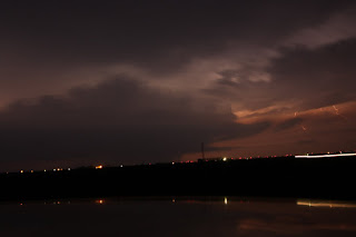
We followed the storm northeast to near Odebolt. It was dark by this time, but lightning was amazing and gave us pretty good views of several wall clouds. We saw a finger-like tornado drop down straight north of us. I'm not sure exactly where or when, but we also witnessed another touchdown sometime around this one. I think it was from another mesocyclone just to the east of this tornado.
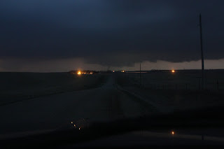
We kept on northeast and made it to Highway 20. We stopped on some county roads which were apparently south of Fonda to take some more pictures of the mesocyclone which was a bit more distant now. We could see the wind farm lights flashing to the north and northeast. While watching the base, we witnessed another finger-like tornado touch down.
We decided to call it a night shortly after this and headed back to Des Moines.
Lessons learned: I love chasing in areas with a great road network, with the usual mile x mile section county roads. It makes chasing possible without too many fancy gadgets. We never used radar after we got on the storm - ALTHOUGH it would have been nice and have allowed us to get closer and better views. I try not to get too close. I really need to work on learning how to use my camera, LOL. And I really need to get a tripod, although with the crazy inflow this storm had, it might not have helped a whole lot. It's time to invest in a video camera as well. It would have made trying to get night shots of the tornadoes a lot easier.
Great chase day! Caught 4 tornadoes (confirmed). Thoughts and prayers go out to those affected by the storms tonight.

As the storm approached we began to realize that there was a tornado tucked back in there, and I was able to capture a few pictures from a distance of the Mapleton tornado. We could see the lowering and the dusty appearance it had underneath. We were some distance from it - you can see how wide the circulation was on the ground. The inflow was insane!

We followed the storm northeast to near Odebolt. It was dark by this time, but lightning was amazing and gave us pretty good views of several wall clouds. We saw a finger-like tornado drop down straight north of us. I'm not sure exactly where or when, but we also witnessed another touchdown sometime around this one. I think it was from another mesocyclone just to the east of this tornado.

We kept on northeast and made it to Highway 20. We stopped on some county roads which were apparently south of Fonda to take some more pictures of the mesocyclone which was a bit more distant now. We could see the wind farm lights flashing to the north and northeast. While watching the base, we witnessed another finger-like tornado touch down.

We decided to call it a night shortly after this and headed back to Des Moines.
Lessons learned: I love chasing in areas with a great road network, with the usual mile x mile section county roads. It makes chasing possible without too many fancy gadgets. We never used radar after we got on the storm - ALTHOUGH it would have been nice and have allowed us to get closer and better views. I try not to get too close. I really need to work on learning how to use my camera, LOL. And I really need to get a tripod, although with the crazy inflow this storm had, it might not have helped a whole lot. It's time to invest in a video camera as well. It would have made trying to get night shots of the tornadoes a lot easier.
Great chase day! Caught 4 tornadoes (confirmed). Thoughts and prayers go out to those affected by the storms tonight.
Subscribe to:
Posts (Atom)