Hey everyone!
Well, I have to admit it. 2009 officially sucked as far as severe weather in central Iowa, as you can guess by the sparse amount of posts here. There just hasn't been much to show you!
Don't be too sad, though! I'll be adding posts to fill in any gaps I may have missed in the past few months, including one of the best chases I've been on. And, winter is not too far off, as some in Iowa can attest to already! I will be showing off anything exciting that happens here concerning winter weather, so stop by every now and then to see what's been happening.
And don't forget, there's always next year. :-)
Tuesday, October 13, 2009
Wednesday, July 1, 2009
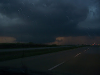
June 7th, 2009: Des Moines, IA Supercell
Up to this point, it has been a very uneventful severe weather season for most of Iowa. All of the action had been bottled up farther south and west, on the plains. Thus, there aren't very many reports for the season. I am now working on adding the few chases I have been on.
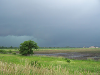
On Sunday, June 7th, while watching the main show of the day online farther southwest, a supercell formed near Atlantic, IA and rode a boundary in central Iowa along I-80 towards Des Moines. This storm produced a brief tornado near Adair, IA and a couple just west and northwest of Des Moines.
I left Ames with a friend for an intercept near Des Moines. I did not like the idea of a city intercept, but I had to work with what I was being presented. We took I-35 south to I-80 west as the storm approached. We heard of the reported tornado west of Des Moines just a little while earlier, and pulled off of I-80 on the north side of Des Moines just ahead of the storm.
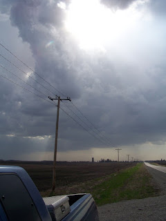
Here is a picture looking northwest as the tornado sirens were going off. This is probably within 5-10 minutes of the last reported tornado of the storm. You can see a wall cloud in the distance in the center of the picture. The storm was a high-precipitation beast, and it was hard to get good pictures. Even harder was trying to get in a good position to see anything noteworthy anyways.
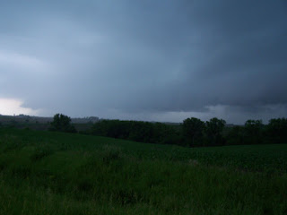
Shortly after we were pounded with heavy rain and had to find an exit on the interstate to turn around on. City chasing sucks, being on an interstate is even worse (especially going the wrong way...). We got ahead of the storm eventually and followed it northeast. The storm was still tornado warned at this time. We couldn't see much, but the storm was beautiful for a HP.

Farther east, the storm is now just severe warned and we decided to call it a night.
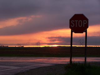
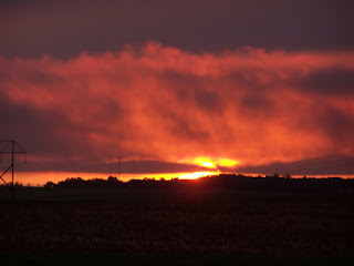
These sunset shots were taken after we passed the storm on I-80 and we found an exit. Very cool!
Overall it was a decent chase for as late as we left. I should have left sooner, but I wasn't sure how it would hold up since conditions weren't as favorable. It rode the boundary and did what it could. This was also my buddy's first storm chase, and he had a good time!
On Sunday, June 7th, while watching the main show of the day online farther southwest, a supercell formed near Atlantic, IA and rode a boundary in central Iowa along I-80 towards Des Moines. This storm produced a brief tornado near Adair, IA and a couple just west and northwest of Des Moines.
I left Ames with a friend for an intercept near Des Moines. I did not like the idea of a city intercept, but I had to work with what I was being presented. We took I-35 south to I-80 west as the storm approached. We heard of the reported tornado west of Des Moines just a little while earlier, and pulled off of I-80 on the north side of Des Moines just ahead of the storm.
Here is a picture looking northwest as the tornado sirens were going off. This is probably within 5-10 minutes of the last reported tornado of the storm. You can see a wall cloud in the distance in the center of the picture. The storm was a high-precipitation beast, and it was hard to get good pictures. Even harder was trying to get in a good position to see anything noteworthy anyways.

Shortly after we were pounded with heavy rain and had to find an exit on the interstate to turn around on. City chasing sucks, being on an interstate is even worse (especially going the wrong way...). We got ahead of the storm eventually and followed it northeast. The storm was still tornado warned at this time. We couldn't see much, but the storm was beautiful for a HP.

Farther east, the storm is now just severe warned and we decided to call it a night.

These sunset shots were taken after we passed the storm on I-80 and we found an exit. Very cool!


Overall it was a decent chase for as late as we left. I should have left sooner, but I wasn't sure how it would hold up since conditions weren't as favorable. It rode the boundary and did what it could. This was also my buddy's first storm chase, and he had a good time!
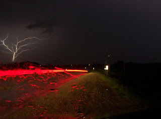
May 31st, 2009: Ames, IA
I watched storms building on radar in the area, and I decided to try to get some lightning shots. I only managed to get a couple, as most bolts were embedded within the rain and it was raining when I took these shots.
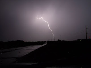
This one is really neat, lightning arcing off of a distant radio tower. A car drove by during the shot, which created the red glow of their taillights as they passed by.

This one is really neat, lightning arcing off of a distant radio tower. A car drove by during the shot, which created the red glow of their taillights as they passed by.

May 9th, 2009: Central Iowa
I was heading home on this day, knowing that I would potentially cross the path of some storms. Well, the storms fired and I planned my route for the closest intercept at the best place possible. There were no tornado warnings, just a few severe warnings. Thus, I found the "tail-end Charlie" on I-80 3o miles west of Des Moines and watched as it passed by. Nothing too exciting, a brief downpour and some neat scenery.


Wednesday, April 29, 2009
April 24th, 2009: North Central Iowa
First chase of the 2009 season!!
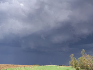
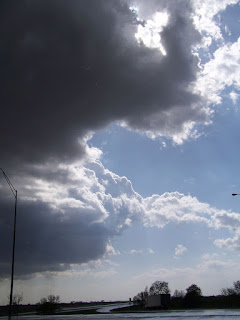
Friday afternoon, my friend and I left Ames at about 3 PM and headed north on I-35 towards Mason City, IA. We stopped for data at the rest stop by Dows, IA. We continued north on the interstate until a few miles south of Mason City. We headed east to get a better view of the storms building to our north and west.
We were watching a particular cell to our west that had a really well defined rain/hail shaft and there was some nice lightning around. We never ventured into the storm to sample the hail (quarter sized hail was reported).

The storm became kind of messy and based on the advice of our nowcaster (Thanks, Bill Schintler!) we dropped south towards Hampton to view another severe warned cell. It was not as "impressive" as the first cell with similar structure. All of these storms were deprived of moisture and had very high bases, not good for tornadoes. After watching it for a bit, we decided to head back towards Ames and drove through more storms along the way, treated with moderate/heavy rain and some close lightning.

I really need to practice different lighting conditions with my camera more often. Not to mention upgrade my camera to something nicer with a bulb setting that I could use for lightning. We stopped near a wind farm by Zearing, IA hoping to get some lightning strikes with the windmills in the background, but the storm in the area was weakening and the strikes were too infrequent for my limited 16 second exposure time on my Kodak. I will return to that spot again sometime to try lighting with that background though!!
Fun chase to start the season, can't wait for the "real" storms to make their way farther north into Iowa later in the season so I can see something a little more worthwhile next time...
Friday afternoon, my friend and I left Ames at about 3 PM and headed north on I-35 towards Mason City, IA. We stopped for data at the rest stop by Dows, IA. We continued north on the interstate until a few miles south of Mason City. We headed east to get a better view of the storms building to our north and west.

We were watching a particular cell to our west that had a really well defined rain/hail shaft and there was some nice lightning around. We never ventured into the storm to sample the hail (quarter sized hail was reported).

The storm became kind of messy and based on the advice of our nowcaster (Thanks, Bill Schintler!) we dropped south towards Hampton to view another severe warned cell. It was not as "impressive" as the first cell with similar structure. All of these storms were deprived of moisture and had very high bases, not good for tornadoes. After watching it for a bit, we decided to head back towards Ames and drove through more storms along the way, treated with moderate/heavy rain and some close lightning.

I really need to practice different lighting conditions with my camera more often. Not to mention upgrade my camera to something nicer with a bulb setting that I could use for lightning. We stopped near a wind farm by Zearing, IA hoping to get some lightning strikes with the windmills in the background, but the storm in the area was weakening and the strikes were too infrequent for my limited 16 second exposure time on my Kodak. I will return to that spot again sometime to try lighting with that background though!!
Fun chase to start the season, can't wait for the "real" storms to make their way farther north into Iowa later in the season so I can see something a little more worthwhile next time...
June 9th, 2008 Lightning
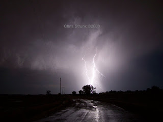
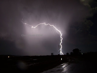
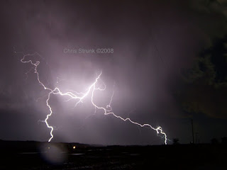
This was a very local and lucky chase for me. The storm came to where I was located at the time, in St. Joseph, MO. It was an isolated supercell that moved across northeast Kansas. I tracked it on radar from my apartment and came to the conclusion that it would hold together and come very close to where I was at.
I took off to the southwest side of town to meet the storm. The storm was upon me at this time, and I encountered heavy rain and some dime sized hail. It was a fairly small storm. I let the rain subside and noticed that the lightning was very intense in a localized area, so I tried some lightning pictures and came out with my best series of lightning that I have taken to date, managing to capture multiple bolts quite well (for my standards!).
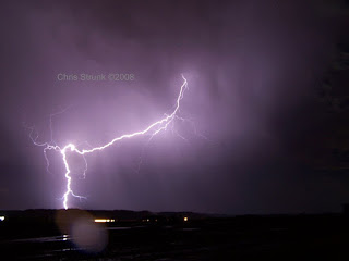
I really hope I am treated to a similar storm this season. This was an easy chase - I didn't have to travel more than 10 miles!
I took off to the southwest side of town to meet the storm. The storm was upon me at this time, and I encountered heavy rain and some dime sized hail. It was a fairly small storm. I let the rain subside and noticed that the lightning was very intense in a localized area, so I tried some lightning pictures and came out with my best series of lightning that I have taken to date, managing to capture multiple bolts quite well (for my standards!).


I really hope I am treated to a similar storm this season. This was an easy chase - I didn't have to travel more than 10 miles!
May 1st, 2008 Chase Account
This was a chase that I tagged along with Scott Bell for. He was gracious enough to let me ride with him for the day. It is the only chase that I have been in where I have had access to the internet while on the road through a cell phone provider. He had a laptop with the internet and GPS set up while we were chasing. It really is nice to have these amenities available to you while chasing, but it doesn't mean you will make the right decisions and get on the best storm... however, it sure doesn't hurt!
We left St. Joseph, MO in the afternoon (where I was located at the time) and took the interstate towards Emporia, KS where we watched the storms build. We left the freeway as we planned an approach for this storm:

We made our way to the business end of the storm. It never could get it's act together, and this was our view of the updraft region:

The storms were forming into line and we decided to follow them back home. Along the way, we approached a tornado warned cell and viewed this lowering as light was beginning to fade. I do not know if there was a tornado produced from this storm or not, but it sure looked mean! Here is a blurry picture that I took as we stopped to assess the situation:
Again, for this chase I must give a big thanks to Scott Bell who let me tag along. It's too bad we didn't end up on a better storm, but that's how it goes when you are chasing! I still had a blast and hopefully I'll meet up with him again sometime in the future.
We left St. Joseph, MO in the afternoon (where I was located at the time) and took the interstate towards Emporia, KS where we watched the storms build. We left the freeway as we planned an approach for this storm:

We made our way to the business end of the storm. It never could get it's act together, and this was our view of the updraft region:

The storms were forming into line and we decided to follow them back home. Along the way, we approached a tornado warned cell and viewed this lowering as light was beginning to fade. I do not know if there was a tornado produced from this storm or not, but it sure looked mean! Here is a blurry picture that I took as we stopped to assess the situation:

Again, for this chase I must give a big thanks to Scott Bell who let me tag along. It's too bad we didn't end up on a better storm, but that's how it goes when you are chasing! I still had a blast and hopefully I'll meet up with him again sometime in the future.
2007 Summer Harvest Storm Pics
This was the 3rd summer in a row that I had partaken in summer custom wheat harvest for my uncle who was the boss of Strunk Harvesting, Inc. I had a lot of fun every summer and have some great stories from each summer. There was a lot of hard work involved, but there seemed to always be time for fun as well.
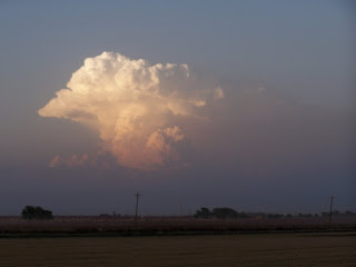
During the summer of 2007 I traveled from north Texas to North Dakota, while stopping in Oklahoama, Kansas, Colorado, and South Dakota in between. In Texas I saw some mean storms, such as this one from a distance:
When I made it to Colorado, I witnessed several powerful supercells. The first one produced large hail just east of where we were cutting wheat on July 11, 2007. It managed to rain us out for half of a day. Here is a picture of it east of our location:

The next day, more supercells built up and moved to the location where we were harvesting wheat. We would always cut as much as possible until we were rained out, and while we were finishing up as the thunderstorm engulfed us, we saw this to our southwest as rain and hail began to fall on July 12, 2007l:


It never did make it all the way to the ground, but it sure provided some excitement for the crew that day. It's something I'll never forget.
During the summer of 2007 I traveled from north Texas to North Dakota, while stopping in Oklahoama, Kansas, Colorado, and South Dakota in between. In Texas I saw some mean storms, such as this one from a distance:

When I made it to Colorado, I witnessed several powerful supercells. The first one produced large hail just east of where we were cutting wheat on July 11, 2007. It managed to rain us out for half of a day. Here is a picture of it east of our location:

The next day, more supercells built up and moved to the location where we were harvesting wheat. We would always cut as much as possible until we were rained out, and while we were finishing up as the thunderstorm engulfed us, we saw this to our southwest as rain and hail began to fall on July 12, 2007l:


It never did make it all the way to the ground, but it sure provided some excitement for the crew that day. It's something I'll never forget.
August 10th, 2007 Lightning Pics
This is a storm that approached me at my parent's house from the northwest. It was part of a squall line advancing to the southeast. It had some nice lightning, so I decided to give it a try as it got close to home. Here are my results:


Here is one of my favorite pictures I have taken to date, got lucky with this one!!!


Here is one of my favorite pictures I have taken to date, got lucky with this one!!!

Tuesday, April 28, 2009
August 8th, 2007 Chase Account
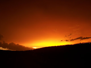
This was another chase that started from my parent's house while I was at home. I was following severe weather moving into northwest Missouri which had been garnering tornado warnings along the way.
I called up a friend and we decided that we would blast south and try to beat the storm headed northeast. As we drove 10 miles to the south, we quickly realized that the storm was gaining speed and we would not be able to get around it in time. So we tried going east to get out ahead of it. We managed to make up some ground and again tried to blast south. We watched a massive shelf cloud overtake us and we were soon enveloped in heavy rain and gusty winds.
We waited out the rain before heading a little west. We were awestruck by the scene of the sunset... everything was glowing orange and red! Here are a couple of pictures of the sunset:

The storm was highly electrified, so we waited until dark and tried some lightning photography. These are some of my first lightning pictures. The first one is an anvil crawler with a utility truck that happened to drive by while I was in the middle of taking the picture. I think it added a cool effect:

Here is another decent anvil crawler:

This was a fun, local chase that ended up yielding some nice pictures. I later learned that the storm produced a short-lived tornado to our southwest as we were trying to get around it.
I called up a friend and we decided that we would blast south and try to beat the storm headed northeast. As we drove 10 miles to the south, we quickly realized that the storm was gaining speed and we would not be able to get around it in time. So we tried going east to get out ahead of it. We managed to make up some ground and again tried to blast south. We watched a massive shelf cloud overtake us and we were soon enveloped in heavy rain and gusty winds.
We waited out the rain before heading a little west. We were awestruck by the scene of the sunset... everything was glowing orange and red! Here are a couple of pictures of the sunset:


The storm was highly electrified, so we waited until dark and tried some lightning photography. These are some of my first lightning pictures. The first one is an anvil crawler with a utility truck that happened to drive by while I was in the middle of taking the picture. I think it added a cool effect:

Here is another decent anvil crawler:

This was a fun, local chase that ended up yielding some nice pictures. I later learned that the storm produced a short-lived tornado to our southwest as we were trying to get around it.
May 5th, 2007 Chase Account and Subsequent Flooding
This was more of a "Hey, everyone, look at that!" chase, than anything. I was at my parents house near Shenandoah, IA at a get-together with some of our family friends. I had been checking the weather everyone now and then, between being outside and grilling, so I knew there was a threat for severe weather.
As the afternoon turned to evening, I watched a storm build to the southwest heading to the north. It ended up passing within a fairly close distance to our house. As we were in our garage outside eating dinner, we heard the tornado warning being issued for the storm over the radio. I ran around the house to get a better look, and sure enough there was a very large wall cloud 5-6 miles west of where we were.
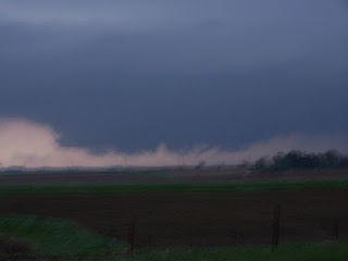
I jumped in a vehicle with an older friend of mine who also enjoys chasing local storms and tried to get closer. The storm was moving pretty rapidly to the north, and we tried to keep up with it. I am not a professional photographer by any means (although I am improving!), so I was only able to grab a blurry picture of the wall cloud, but it shows up well enough! We chased the storm for about 20 miles and were able to catch the area of rotation, but never saw a tornado. By this time it was getting dark and we called it off.
We later learned of tornado touchdowns along the path of the wall cloud (that we did not observe). There was an EF1 tornado that had a path length of approximately 11 miles from a few miles north of Farragut, IA to near Imogene, IA. One of the farms to sustain damage was none other than that of my friend's parents, while my friend was still at my house eating dinner! They lost a grain bin, the roof to their machine shed, and some trees.
Here is my only decent picture of the wall cloud:
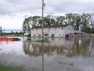
Later that night, heavy thunderstorms pounded southwest Iowa with heavy rain. Over the next couple of days, Shenandoah, IA suffered from some of the worst flooding it had seen in a while.
Here are a few pictures that I took by the edge of town:


I will be working on adding my next storm account soon!
As the afternoon turned to evening, I watched a storm build to the southwest heading to the north. It ended up passing within a fairly close distance to our house. As we were in our garage outside eating dinner, we heard the tornado warning being issued for the storm over the radio. I ran around the house to get a better look, and sure enough there was a very large wall cloud 5-6 miles west of where we were.
I jumped in a vehicle with an older friend of mine who also enjoys chasing local storms and tried to get closer. The storm was moving pretty rapidly to the north, and we tried to keep up with it. I am not a professional photographer by any means (although I am improving!), so I was only able to grab a blurry picture of the wall cloud, but it shows up well enough! We chased the storm for about 20 miles and were able to catch the area of rotation, but never saw a tornado. By this time it was getting dark and we called it off.
We later learned of tornado touchdowns along the path of the wall cloud (that we did not observe). There was an EF1 tornado that had a path length of approximately 11 miles from a few miles north of Farragut, IA to near Imogene, IA. One of the farms to sustain damage was none other than that of my friend's parents, while my friend was still at my house eating dinner! They lost a grain bin, the roof to their machine shed, and some trees.
Here is my only decent picture of the wall cloud:

Later that night, heavy thunderstorms pounded southwest Iowa with heavy rain. Over the next couple of days, Shenandoah, IA suffered from some of the worst flooding it had seen in a while.
Here are a few pictures that I took by the edge of town:


I will be working on adding my next storm account soon!
Opening Post!
Well here it is, my first blog post. I will soon be adding brief accounts and a few pictures from previous chases and other weather pictures that I have taken. I just went on a storm chase last Friday, which will also be posted soon. Be sure to check back throughout the rest of the severe weather season, it looks as if this storm chasing season is gearing up to be an active one!
Subscribe to:
Posts (Atom)