Wednesday, June 17, 2015

May 10th, 2015 - Hillsboro, Texas Tornadic Supercell

This was a stormy Mother's Day 2015 for many in Texas. Storms exploded west of I-35 in Central Texas early in the afternoon. By 4 pm I finally made the decision to head out the door and chase. It had been nearly two years since I had last done so. Life has a way of keeping you away from the things that you enjoy, sometimes. But here I was, on the highway and calling mom and grandma to wish them a happy Mother's Day and heading west. My plan was to intercept a tornado warned storm moving towards Hillsboro, Texas, and that's exactly what I did. The photo below is what I encountered just east of Hillsboro on TX-22 highway.
I was chasing alone and did not want to encounter any hail, so I stayed east and south of the storm that was moving east. As the storm approached, I had to move. I'm used to chasing in Iowa and we normally have road options every mile or so in a square grid pattern. In those areas it is much easier to navigate. This is definitely not the case in Texas. There's not a straight road anywhere. As such, I was trying to navigate, watch radar, and watch the storm all the time which is also why I had to keep my distance even more. I went south.
The circulation was moving more to the northeast at this time, so I decided to head back north a ways. It was a challenge to find good views among the hills and trees. After moving between a few different spots, I found this nice view as the circulation was really wrapping up nicely. I took the photo below I believe about the same time that a tornado was reported in that rain-wrapped mess.
I was snapping pictures at this location and got lucky with a daylight bolt of lightning.
I tried to follow the circulation but road options were a mess and it was getting dark. I called it a chase and headed east hoping that I'd find some spots to shoot some lightning photos. The storms didn't cooperate very well. Other storms were firing out ahead of the main line which caused too many clouds for good lightning pictures. Some even went tornadic, including the storm that produced and EF-3 tornado that hit Van, TX. I made it home and took a few lightning pictures in my backyard after the storms rolled through my area.
It felt good to get out and chase a beautiful storm, although my mood was dampened after hearing about the devastation in Van, TX.

Friday, April 5, 2013

April 5th, 2013: Update

It's been a while since I have updated this blog, so I figured I might try to do a better job at keeping it updated. 2012 was a slow year for me, between work and not doing much chasing overall. I hope to have a few more opportunities this year. I do, however, have a few more pictures that I will be adding soon. Sometimes if you can't chase the storms, they will chase you, and that has been the case at least a couple times. That's the great thing about weather. It's always around you no matter what you are doing, it's just a matter of time before something interesting pops up! So check back within a few days and I should have some more interesting posts for you to take a look at!

Thursday, June 16, 2011

June 16th, 2011 - Update

Well after a somewhat promising start for the area in April, May into June has been very disappointing in the East Texas area where I now reside. There have been a few spotty thunderstorms in the area from time to time, but it has been very hot and dry for the most part as an upper ridge has settled into the area for quite some time now. I am hoping for some relief in the form of slightly cooler temperatures and increased thunderstorm chances by the middle of next week. The chase season may be over in this region, but I would like to see more thunderstorms in the area to help with the drought and maybe give me an opportunity to shoot some lightning! We'll just have to see what the summer is going to bring me.

Sunday, April 24, 2011

April 23rd, 2011 - Sherman, TX Supercell, Wallclouds, and Lightning

I intercepted a beautiful supercell just west of Sherman, TX. This storm produced several awesome wall clouds. There were a couple reports of brief tornado touchdowns, but I did not witness any. I didn't always have the best vantage point and I stayed back for some fantastic storm structure photography.


In these next two images, the wall cloud becomes really well defined and starts to crank up. Too bad for those trees in the way which blocked any view of the ground, but it did not look like any tornadoes touched down from these views. It was close! I just don't think we had enough low level inflow into the storm to get the job done.


I moved to different location to get a closer view. The wall cloud was becoming less defined now, although it did put out some weak funnels which didn't amount to much. This storm was starting to get overrun by convection from the west and began to look more linear. I could feel cool outflow eventually before I left.


On the way back home I stopped and took a few decent lightning pictures. A nice end to a good chase!


Happy Easter everyone!

Saturday, April 16, 2011

April 14th, 2011 - Tushka, Oklahoma

Storms fired along a dryline through Kansas and Oklahoma late in the afternoon. After getting off a late start, I left Tyler, TX and headed northwest towards the Red River Valley, where I hoped storms would continue to fire along the dryline into north central Texas. I stopped for data when I reached Bonham, TX. No storms fired to my west, but I could see the monster supercell in Oklahoma off in the distance. I decided to head north into Oklahoma even though it would be near sunset by the time I could intercept. The road options in this area are terrible. I followed Bob's Road to continue in a northward direction. I eventually had a pretty good view of the storm from the south, but I was still a good distance away.

I realized that it would be too dark to attempt any meaningful intercept of the storm, but since I had already come this far I wanted to attempt some lightning photography. I continued driving closer to the storm, having to zig-zag along the Oklahoma highways. I made it to US 69 and drove northeast. The storm looked very intense, and a tornado warning was issued. I followed an ambulance from a distance. I was looking for a suitable place to take pictures from, but trees and valleys offered pitiful views. I told myself I would not go any farther than Tushka, since going any farther north would put me in the path of the storm heading that way.

I eventually ran into a damage path as I approached Tushka from a tornado that went through there less than an hour earlier. The town smelled strongly of freshly mowed wet grass. I saw overturned semis, downed powerlines/trees, and damaged buildings. It was not a good feeling at all to drive into a town after it was just hit by a tornado, seeing rescue efforts in full force. I turned around and headed back home since I had no emergency gear to help in my vehicle. I didn't want to get in the way any more than I already was. I was very sad to hear about the two fatalities. My thoughts and prayers are with this community.

This experience has definitely reaffirmed the need for me to put together an emergency kit in case I come across the damage path of a tornado on future chases. Many storm chasers have such a kit to some extent, and many will end their chase to stop and help search and rescue efforts in tornado damaged houses/communities. Kudos to all other storm chasers who have stopped to help storm victims in any way.

Sunday, April 10, 2011

April 9th, 2011 - Northwest Iowa Monster Supercell

Wow, what an evening. I chased with a friend of mine, who had never been chasing before. We left Des Moines around 2:30 PM and headed west to Avoca, IA. Stopped for some data at the Pilot truck stop. Nothing was happening yet so we killed some time and drove around a state park a little ways to the north. Then we went to Harlan, IA and found another WIFI hotspot and got more data. By this time the storm of the day had initiated in Nebraska. I waited around for just a little while to see if anything looked like it would develop farther south, but finally made the decision to intercept. We went north to Denison, IA, but could not find any WIFI quickly, but heard the thunderstorm warning and then the first tornado warning for Monona county to our northwest and headed northwest to Charter Oak, IA. By this time the beautiful mesocyclone became obviously apparent. We took some county roads north and parked on top of a hill somewhere west of of Ricketts, IA.


As the storm approached we began to realize that there was a tornado tucked back in there, and I was able to capture a few pictures from a distance of the Mapleton tornado. We could see the lowering and the dusty appearance it had underneath. We were some distance from it - you can see how wide the circulation was on the ground. The inflow was insane!


We followed the storm northeast to near Odebolt. It was dark by this time, but lightning was amazing and gave us pretty good views of several wall clouds. We saw a finger-like tornado drop down straight north of us. I'm not sure exactly where or when, but we also witnessed another touchdown sometime around this one. I think it was from another mesocyclone just to the east of this tornado.


We kept on northeast and made it to Highway 20. We stopped on some county roads which were apparently south of Fonda to take some more pictures of the mesocyclone which was a bit more distant now. We could see the wind farm lights flashing to the north and northeast. While watching the base, we witnessed another finger-like tornado touch down.


We decided to call it a night shortly after this and headed back to Des Moines.

Lessons learned: I love chasing in areas with a great road network, with the usual mile x mile section county roads. It makes chasing possible without too many fancy gadgets. We never used radar after we got on the storm - ALTHOUGH it would have been nice and have allowed us to get closer and better views. I try not to get too close. I really need to work on learning how to use my camera, LOL. And I really need to get a tripod, although with the crazy inflow this storm had, it might not have helped a whole lot. It's time to invest in a video camera as well. It would have made trying to get night shots of the tornadoes a lot easier.

Great chase day! Caught 4 tornadoes (confirmed). Thoughts and prayers go out to those affected by the storms tonight.

Thursday, May 13, 2010

May 12th, 2010: Central Kansas Chase

Another disappointing chase. I started the day in St. Joseph, watching the progress of a warm front in Kansas and southern Missouri as it moved northward. The front stalled out along I-70 and the only clearing that was taking place was in southern Kansas.

I made my way towards Lawrence, Kansas. I stopped for data just outside of town. A tornado watch was issued for central and southern Kansas. It became obvious that eastern Kansas was not going to do anything with all of the crap-vection and clouds in the area, limiting instability along the warm front.

I teamed up with a fellow storm chaser from Topeka and decided to head south and west. We met up at a gas station along I-35 and Hwy 75. There were tornado warnings on a couple of supercells that had formed in south central/central Kansas. It was a little surprising to me that these storms got their act together, after initially looking like linear, outflowish junk. But they did, and we made a plan to head west of Emporia and try to get close to the line of storms.

The storms looked pretty good for a while, but as we got closer to Emporia, they started to lose their supercellular characteristics and turned back into linear junk. Just great. We had come this far, so we decided to continue and just try to see whatever we could. We stopped in Florence just ahead of the line of storms. Nothing looked good, and we didn't even have a very clear view of the storms. We waited for a while and finally it looked like the end of the line segment to our west was growing in strength and would head directly for town. It wouldn't have much of a tornadic threat at all, but maybe it would be interesting to look at, we thought.

We headed a few miles south of town and pulled off on the top of hill (in the Flint Hills, if you are on the top of a hill you can see forever). The storm was producing outflow clouds that I have seen referenced as a "whale's mouth" because of the way they slope back upwards on the backside of them. There was a decent hail core on the southern end of the line and it skirted past us to the north.


We took the opportunity to take a few scenic pictures and headed back to Florence. We saw a report of 1" hail from the sheriff in town, and he was right. There was a pretty good amount of 1" hailstones. I'm glad we decided to head south since we were in my truck...


All in all, another disappointing Kansas chase this week where being out of position ruined any opportunity of seeing a nice supercell storm. It looks like my chasing opportunities will be slim until I moved to east Texas in a couple of weeks. Not sure how many opportunities I will have after that... stay tuned!

I'd like to thank my chase partner, Zach, for joining up with me and providing radar/data and Mike Johnston for providing nowcast support.

Tuesday, May 11, 2010

May 10th, 2010: SE Kansas Chase

I finally graduated school! There has not been any interesting weather occurring in Iowa when I've had any time to chase. Now that I've finished school, I have a couple of weeks before I move to Texas and start my new job!

I teamed up with Scott Bell and chased the extremely hyped severe weather setup in SE Kansas and Oklahoma. We left Maryville, MO before 1 PM, after Scott could get away from work. It is always best to get to your target area well before storm initiation, but it doesn't always work out that way.

We were targeting Wichita, KS. We got on the interstate and headed southwest. Storms began to blow up in SW and SC Kansas, and eventually NW Oklahoma. And the race was on, with 45-55 kt storm motions to the NE.

We decided that we needed to target the supercell in Oklahoma that was going to cross into Kansas, as in our position was about our only option. We could have went west into Wichita to chase a supercell west of town, but decided that chasing in a metro area would be a bad idea. That storm ended up being choked off by other convection before we could have ever been close.


Our storm looked fantastic on radar (well, actually all three supercells in SC Kansas through NW Oklahoma looked amazing at one time or another). As we approached the storm and got into position near Longton, KS on the southeast side of it, it died. In the picture above, our location is represented by the yellow dot with a circle around it, to the northeast of the storms. You can tell that our storm just to the southwest of us is started to die. It was ingesting cool air as we were on the cool side of the warm front. We were too late. We couldn't even see the storm visually due to low clouds blanketing the sky.

We headed back north and got munched by a line of severe thunderstorms that had fired along the dryline. Nothing much to note, except for heavy rain. We did notice some of the most interesting feeder bands I've ever seen that were feeding the line of storms. The clouds were literally forming from condensation rising off of the ground, right out of the trees. If you enlarge the picture below, you can see it lifting off of the trees down the hill. These clouds were then sweeping towards the severe storms to our west, feeding them. It was very creepy.


Later we sat northeast of Emporia, KS and watched a linear severe warned storm. It had some cool structure (best of the day by far) and was a nice treat to an otherwise disappointing chase.

Thursday, March 11, 2010

2009-2010 Iowa Winter

Well, if you were in Iowa this winter, you know it was one of the snowiest we've ever had in the state. It is definitely the worst that I can remember (granted, I'm not THAT old just yet :-P).

The first blizzard came a week into December for the Ames area. The storm dumped around 13" of snow and 40+ MPH winds. Here's my poor truck braving the cold...


The next storm was the Christmas Eve/Day Blizzard which I endured back home in southwest Iowa. Our town reported 15.5" of snow. We ended up with a lot of big drifts, after having only been hit with the prior storm a couple weeks prior. This storm snowed us in for 2 days before our neighbor came to dig us out!


On the way back to Ames a few days later, I stopped at a rest stop about 30-40 miles west of Des Moines. Instead of a huge blizzard, they had one nasty ice storm there.


I got tired of taking pictures of snow, so I don't really have very many others. It was a brutal winter! I ended up being in 3 blizzards and many other winter storms as well. The worst part of the winter was the below average temperatures. In a normal winter, the temperatures will rise above freezing every once in a while, melting away at least some of the snow throughout the season. This winter, we did not rise above freezing after the first Blizzard in December, allowing each storm to pile on top of the previous one. We spent much of this winter with 15-20"+ of snow on the ground!

I am glad that we have finally risen above freezing and have experienced plain rain for the past few days. I am ready for spring and severe weather season!! I would not be surprised, though, to see at least one more blast from "Old Man Winter" before winter is officially over. We'll see!

Monday, March 8, 2010

June 21st, 2009: Grundy Center - Waterloo Supercell

I apologize to anyone who has been waiting for me to post updates or see what's been happening lately.

Here is my account from the June 21st, 2009 Grundy Center to Waterloo chase -- My best chase to date!

I was heading back to Ames from southwest Iowa. I knew there was a potential for activity in central/northern Iowa that afternoon. As I approached Des Moines, I noticed storms going up to the north and shortly afterwords, tornado warnings were being issued. I made the decision to head north and try to catch the storms.

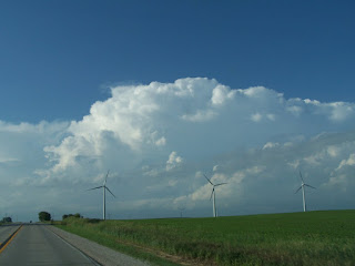
Here is a picture of the storm as I was heading north on US65 somewhere near Zearing, IA.


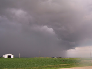
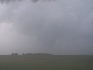
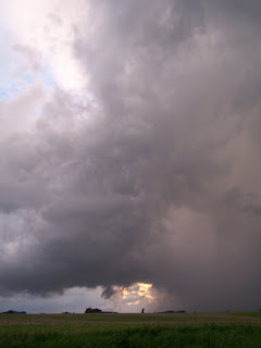
I then took Highway 175 to the east and tried to catch up with the storm. The road put me in perfect position to just get by the southern edge of the storm, without getting into very much precipitation. Somewhere east of Eldora, IA I was finally on the southern edge of the storm. Here is a picture of the mean-looking precipitation core from the "hook" part of the storm, as I am looking to the northeast.


I continue driving east and ended up making it to Grundy Center. I was in great position to view the storm as I saw on the west side of town and had a great view to the west, northwest, and north. The storm tried very hard to wrap up here. I got out of my air-conditioned truck to take some pictures, and was reminded of a very important storm chasing lesson: bringing your cold camera outside into hot, humid air will cause your lens to fog up! D'oh! Thus, many of my pictures at this location are very foggy. Stupid me. One must always remember to turn down or turn off the A/C as you are approaching a storm you want to photograph!

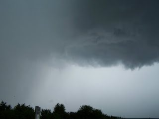
Here is a picture of me on the west side of Grundy Center looking at the beautiful storm wrapping up to my northwest. You can see the clear slot and wrap-around precipitation very easily.


Things began to get a little more interesting as the storm continued to wrap-up. In this picture (starting to get foggy), you can see a funnel cloud forming in the center of the picture.


Here is another foggy picture as I tried to zoom in on the funnel cloud. There was a lot of rotation and I was sure that I was going to see a nice tornado form. It came really close, but I could never see condensation all the way to the ground, so I couldn't tell if it actually touched down or not. I don't remember seeing any reports of an actually touchdown here. But man, it was close!


The storm was moving to the east, and precipitation was starting to close in, and my view was becoming blocked. It was time to move. I headed east through town. The highway began to turn a bit farther south than I wanted to see, so I had to pick a gravel road to get back to the north.

I don't have a GPS or any fancy navigating equipment, so I have to be careful when making navigational decisions close to a dangerous storm. One wrong move could end up positioning me between a wall of hail/rain to the south/west, and the area of circulation (bad place to be under!) to the north. Thankfully in most parts of the state of Iowa, we are lucky to have a grid road system, so there are usually east/west and north/south roads every mile.

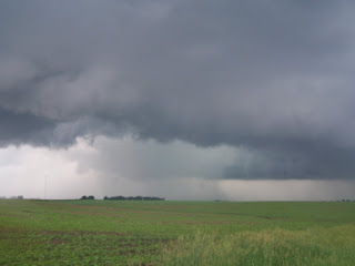
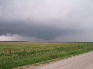
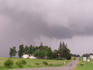
I chose a gravel road and blasted to the north. The storm was quickly approaching from the west, with the hook threatening to overtake me. There was no road at the first mile. I just barely made it to an intersection at the next mile with enough time to take a picture of the precipitation and area of circulation, which were both under a mile away.


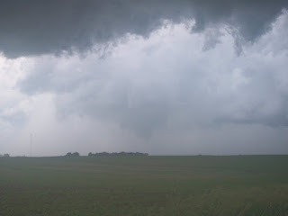
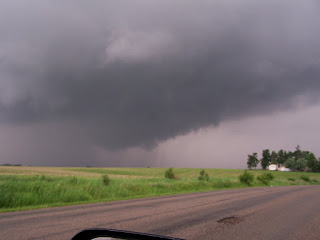
I zig-zagged my way through gravel roads staying ahead of the storm. While the storm was still clearly rotation, it looked less-ominous than it did near Grundy Center. It finally began to look better which gave me renewed hope that it might produce. Here is a picture looking to the northwest at a nice wall-cloud.


A little bit later, I made it to the southwestern edge of Waterloo. The storm was looking downright nasty again to the north/northwest.


On the other hand, with the sun beginning to set, there were some beautiful views off to the west.


The wall cloud was rapidly rotating at reminded me of the scene near Grundy Center earlier. I had a bad feeling that there would be a tornado ripping through Waterloo.


THANKFULLY, the storm lost steam after this, and I never heard of any reports of a tornado here. I tried to find a way to follow it to the east for a bit before it got dark, but the road network through town and around the south side was a big pain, and I called it quits for the day.

All in all, it was an awesome solo chase. I got to see a very beautiful storm come very close to producing a tornado several times. The beautiful views that this storm gave more than made up for not seeing a tornado today.

I wished I would have left home a couple of hours earlier so I could have been on the storm from birth. The storm did produce several weak tornadoes before I was able to catch up with it. I don't believe any touched down after I caught up with it.

--

Again, sorry for not posting this sooner! It has been a nasty winter around here, and I'll try to post some of my various blizzard/winter pictures from Iowa soon.

Tuesday, October 13, 2009

October 13th, 2009: Update

Hey everyone!

Well, I have to admit it. 2009 officially sucked as far as severe weather in central Iowa, as you can guess by the sparse amount of posts here. There just hasn't been much to show you!

Don't be too sad, though! I'll be adding posts to fill in any gaps I may have missed in the past few months, including one of the best chases I've been on. And, winter is not too far off, as some in Iowa can attest to already! I will be showing off anything exciting that happens here concerning winter weather, so stop by every now and then to see what's been happening.

And don't forget, there's always next year. :-)

Wednesday, July 1, 2009

June 7th, 2009: Des Moines, IA Supercell

Up to this point, it has been a very uneventful severe weather season for most of Iowa. All of the action had been bottled up farther south and west, on the plains. Thus, there aren't very many reports for the season. I am now working on adding the few chases I have been on.

On Sunday, June 7th, while watching the main show of the day online farther southwest, a supercell formed near Atlantic, IA and rode a boundary in central Iowa along I-80 towards Des Moines. This storm produced a brief tornado near Adair, IA and a couple just west and northwest of Des Moines.

I left Ames with a friend for an intercept near Des Moines. I did not like the idea of a city intercept, but I had to work with what I was being presented. We took I-35 south to I-80 west as the storm approached. We heard of the reported tornado west of Des Moines just a little while earlier, and pulled off of I-80 on the north side of Des Moines just ahead of the storm.

Here is a picture looking northwest as the tornado sirens were going off. This is probably within 5-10 minutes of the last reported tornado of the storm. You can see a wall cloud in the distance in the center of the picture. The storm was a high-precipitation beast, and it was hard to get good pictures. Even harder was trying to get in a good position to see anything noteworthy anyways.


Shortly after we were pounded with heavy rain and had to find an exit on the interstate to turn around on. City chasing sucks, being on an interstate is even worse (especially going the wrong way...). We got ahead of the storm eventually and followed it northeast. The storm was still tornado warned at this time. We couldn't see much, but the storm was beautiful for a HP.


Farther east, the storm is now just severe warned and we decided to call it a night.


These sunset shots were taken after we passed the storm on I-80 and we found an exit. Very cool!


Overall it was a decent chase for as late as we left. I should have left sooner, but I wasn't sure how it would hold up since conditions weren't as favorable. It rode the boundary and did what it could. This was also my buddy's first storm chase, and he had a good time!

May 31st, 2009: Ames, IA

I watched storms building on radar in the area, and I decided to try to get some lightning shots. I only managed to get a couple, as most bolts were embedded within the rain and it was raining when I took these shots.


This one is really neat, lightning arcing off of a distant radio tower. A car drove by during the shot, which created the red glow of their taillights as they passed by.

May 9th, 2009: Central Iowa

I was heading home on this day, knowing that I would potentially cross the path of some storms. Well, the storms fired and I planned my route for the closest intercept at the best place possible. There were no tornado warnings, just a few severe warnings. Thus, I found the "tail-end Charlie" on I-80 3o miles west of Des Moines and watched as it passed by. Nothing too exciting, a brief downpour and some neat scenery.